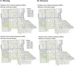
This study evaluates the exposure of school children to gun violence along their walkable routes to and from school in Englewood, Chicago. Using acoustic sensor detection technology (ShotSpotter) alongside realistic network routing models, the research quantifies both direct and indirect gunfire exposure during daily school commutes.
The findings show that children walking to school face frequent and geographically concentrated gunfire exposure, which varies significantly depending on specific walking routes and neighborhood social vulnerability. This work demonstrates the power of integrating spatial routing algorithms with acoustic gunshot data to guide school safety policies, active transit planning, and targeted community policing.