Development and Spatial Validation of a Random Forest Prediction Model for Firearm-Related Injury Risk in Chicago Census Tracts
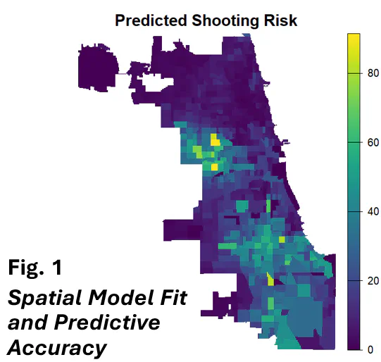 Predicted Shooting Risk - Spatial Model Fit and Predictive Accuracy
Abstract
This research develops and validates a spatial random forest prediction model for firearm-related injury risk at the census tract level in Chicago. By incorporating spatial autocorrelation and neighborhood-level predictors, the model achieves high predictive accuracy in identifying areas at elevated risk for gun violence.
Presentation at Women in Statistics and Data Science Conference
Our presentation, Modeling Firearm Injury Risk Using Spatial Random Forests, was delivered by Dr. Gia Barboza-Salerno at the Women in Statistics and Data Science on November 12, 2025 in Cincinnati, OH.
Abstract
This research develops and validates a spatial random forest prediction model for firearm-related injury risk at the census tract level in Chicago. By incorporating spatial autocorrelation and neighborhood-level predictors, the model achieves high predictive accuracy in identifying areas at elevated risk for gun violence.
Methodology
Spatial Random Forest Approach
The spatial random forest model extends traditional random forest methods by:
- Capturing Non-Linear Relationships: Modeling complex interactions between neighborhood characteristics and shooting risk
- Handling Spatial Autocorrelation: Incorporating spatial structure through lag variables
- Variable Importance: Identifying which neighborhood features are most predictive
- Robust Predictions: Providing out-of-sample risk estimates
Data Sources
- Shooting incident data from Chicago
- Census tract-level socioeconomic indicators
- Built environment features
- Spatial lag variables to capture spillover effects
Model Validation
- Cross-validation for predictive performance assessment
- Spatial autocorrelation diagnostics
- Comparison with traditional regression approaches
Key Findings
The predicted shooting risk map (shown above) demonstrates:
- High Spatial Variation: Risk scores range from 0 to over 80 predicted incidents
- Concentrated Risk: Certain neighborhoods show elevated firearm violence risk
- Model Accuracy: Spatial random forest successfully captures fine-grained risk patterns
- Spatial Clustering: Violence risk exhibits significant spatial autocorrelation
Applications
This spatial prediction model has important applications for:
- Resource Allocation: Targeting violence prevention resources to high-risk areas
- Prevention Planning: Understanding neighborhood-level drivers of gun violence
- Policy Evaluation: Assessing how neighborhood changes affect violence risk
- Early Warning: Detecting emerging hotspots before violence escalates
Implications
The research demonstrates that spatial random forest models can:
- Improve prediction of firearm violence risk beyond traditional methods
- Identify actionable neighborhood-level intervention targets
- Account for complex spatial dependencies in violence patterns
- Support evidence-based violence prevention strategies
Conference: Women in Statistics and Data Science Conference
Location: Cincinnati, Ohio
Date: October 1-3, 2025
Authors: Gia Barboza-Salerno, Hexin Yang, Taylor Harrington

Dr. Gia Elise Barboza-Salerno
Director
I am an interdisciplinary scholar whose research integrates law, public health, social work, and advanced statistics to study childhood adversity, violence-related harm, and neighborhood-level inequities. I lead the ISSUES Lab at Ohio State, translating spatial and legal analysis into policy and practice.

Hexin Yang
PhD Candidate, Methodologist
Hexin is interested in studying child and adolescent development across various contexts, particularly in school settings, using advanced statistical analyses.

Taylor Harrington
PhD Candidate, Methodologist
Taylor Harrington, MS, is a PhD candidate in Public Health at The Ohio State University. To investigate how multi-level factors shape health behaviors and outcomes, she integrates advanced computational and geospatial methods, including machine learning (e.g., computer vision, random forests, structured topic modeling, text mining) and geospatial modeling (e.g., Bayesian spatial modeling, remote sensing). Through this work, she aims to generate actionable evidence to inform equitable health policy and community-level interventions.